There is something left to be told, something really substantial and special that was, in fact, the reason that had us pack up our bags and head out to Arunachal in the first place – Wakro.
But let’s first put a few realities on the table. Not many tourists have Arunachal Pradesh on their travel agenda. Which is just as good for those of us who want to keep their special discoveries all to ourselves!
And if you felt that there is a Tawang, that does catch a few tourists in the peak season, the truth is that there are many more such pearls tucked away in a green oyster that takes more than a touristy attempt at discovery. Scouring for the most popular north-east travel itineraries from the net or walking up to the travel agent office, down the road, will not yield much more than the West Arunachal circuit of Tawang and Bomdila. Which is why we headed to the east of northeast.
Racing across the map
So what do we have to offer which we haven’t already shared with you?
We spent a few moments at the War cemetery at Digboi, drove up the Stillwell road till the Pangsau Pass at the Indo-Burmese border, played with the butterflies and dodged a few leeches in the woods of Namdapha, crossed the Lohit to reach Tezu, headed all the way up to Walong, reached out to distant Kaho and Kibithu and caught the first rays of sun to fall on the Indian subcontinent.
Wakro, Arunachal pradesh (Google Map)
For starters, it happens to be one of the realities that we placed early on the table. Seeing it on the Google map is the stuff that gets the traveller in you to sit up. Typing in just Arunachal Pradesh on Google maps and without zooming in any further, you realise that Wakro is the furthest east that you can get anywhere in India. So much so that half of Burma, including Yangon, lies to its west. So, when we drove into Wakro in Jayanto da’s jeep, we knew we were in the east…seriously east.
As we climb down the mountains – Lohit river
Parashuram Kund Bridge
Descending the last few bends in the ghat from our long drive from Walong, we passed the Demwe point where one road went on to Tezu and the other headed to Parshuram Kund. We took the latter and, shortly, reached the new Parashuram Kund bridge that sprawled across over the Lohit. All along the climb up to Walong and down to Wakro, watching the river from the IB at Walong and crossing over it on the hanging bridges, we had seen Lohit in all its many moods. But this was different. We were staring down at it from really up close and from the ‘comforts’ of a concrete bridge.
Parashuram Kund bridge
Lohit ghats
Ahead, the famous sight of Parshuram’s axe embedded in the riverbed heightened the drama that was already quite dramatic. We parked our Scorpio at the base of the bridge, climbed a few steps till we reached a temple. There were a few men dressed in saffron sitting around a Banyan tree.
Walking to the ghats
We walked further, passed another temple, and a few smaller shrines, and proceeded to climb down the steps that were built to accommodate the thousands of pilgrims who flock here every January during Makarsakranti to take a dip in the freezing waters of Lohit. For now, we were the only people around.
The temples, shrines and holy men on the way to the Kund
Every year, Parshuram Kund Mela is organised in the month of January from 13th to 15th. On Makar Sankranti day, large numbers of devotees come here to take a dip in the waters. Legend says that when Parshuram killed his mother with an axe at the behest of his father, the axe got stuck to his hands. In order to get rid of the axe, and the sin of killing his mother, he came to Brahma Kund where he took a dip in the holy water. Magically, the axe immediately fell from his hands. He picked up the axe and threw it as far as he could into the mountains. The axe split the mountains, and the spot where it fell became the Brahmaputra River.
The axe seen from the Parasuram Kund bridge
Beyond the Parshuram Kund, the Lohit River is known as the Brahmaputra.
Jayantoda told us an interesting fact about Parshuram Kund. During Makarsakranti, only those whose parents have passed away can take a dip in the Lohit River at the Parshuram Kund. The rest take a dip across the Kund in the Brahmaputra River.
The iconic ‘axe’ at Parasuram Kund
Down at the last few steps just above the river, we felt the naked fury of the Lohit as the blacks, the dark greens and the frothy whites all tossed up as if in a super strong blender. In front of us, the “axe” with its jagged edges protruded resolutely over the swirling waters.
Close encounters with the ‘axe’
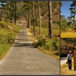
Wakro – almost there
Wakro was just 20 km up ahead. A brief stop for a cup of tea later, we were crossing the Kamlang bridge and waiting with bated breath for the first sight of Uncle Moosa’s ‘home’ town. Uncle, an Arunachali at heart and by the sheer fact that the last 30 years of his life have been spent in Arunachal and among its lovely people, currently works and lives in Wakro.
From here on Lohit is known as the Brahmaputra
For the next five days we would be with Uncle, sharing or rather encroaching upon his space, spending time with him at the Apne library, with his books, with his little patrons from Apna Vidya Bhavan and Kasturba Gandhi Balika Vidyalaya, with the wonderful staff of these fine two schools and, never the least, the two remarkable people who started and run these excellent institutions under the Anu Shiksha Seva Trust (ASSET) with the graceful blessings of His Holiness Swami Sri Sri Anubhavananda Saraswatiji.
Ahh! The much awaited post from the true explorer! Arunachal is still vastly unexplored and I wish I could hide your blog somewhere to hide it from the package tourists!
Arnab, I don’t think any of those ‘package tourists’ would even think of coming this way. But if this would inspire another ‘true explorer’, I would be only happy to show the way :).
Amazing fotos&writeup malini…Always wanted to visit Arunachal, infact hav a friend at tawang. But just not sure abt the law&order issues as will be travelling with kids…hope all izz well..
Thanks Sangeetha. You should visit Arunachal, it is a wonderful place. We did not face any issues as such. There is a strong army presence all over the state and we never had to worry. The only factor that is probably stopping a lot of travellers is the fact that you need an inner line permit to enter Arunachal. Your friend could help you with that.
Wonderful post abt a wonderful place. I have been to this place and this route a number of times. And I don’t think, apart from the ‘procedure’ part, Inner Line Permit is any problem. Having said that, I so wish that this remains open for only the true explorers and not to all Toms, Dicks and Harries as the commercialization will spoil the verdant beauty.
Very true Nivedita. Who would want to see all those plastic covers, that come with those ‘package tourists’, strewn all over the virgin mountains of east Arunachal? Thanks :).
Nice to meet you again in NE at Wakro.. You are really dragging true nature-lovers to Arunachal.. You have a nice pen which sketches beautiful drawings of NE.. People like R B Singh, Dube ji said that you often says, that ‘I must have born here last time’.. I am sure now, you must have.. Well, I also wish to reborn somewhere there.. By the way I witnessed Pangsau Festival last month, but I will advice to avoid this period because the festival fades up the beauty of serene jungle and zigzag historical Ledo Road loses it identity due to socalled ‘tourists’ flood .. The festival denied me to ‘return’ in time from Lake of no return, so I am planning to revisit Pangsau.. and Walong, Kaho, Kibithu also.. I stayed at Jairampur VKV where you have left memories with Dube ji.. and returned -of course- via Lekhapani (the last of East and now abandoned station), Digboi, Dibrugadh, Shivsagar, Jorhat and Kaziranga.. but my eyes were looking at East of NE again and again.. The thirst is unending..
Yes, we meet in Wakro. The place that inspired us to pack our bags and embark on this beautiful journey. You should visit Wakro while it still remains not polluted by those ‘so-called’ tourists.
Crowds do spoil the beauty and rob you of those natural and magical surroundings. I can imagine how desperate you must have felt, seeing the touristy ones.
So happy to know that Dubeyji remembers us. We had already booked ourselves into the IB at Nampong, or else we would have stayed at the VKV in Jairampur. Maybe next time. Guess its time to pack our bags again.
I have enjoyed your blogs very much. One thing about the’axe’ though. Till August, 1950 it was part of the hill side to its left. Then on 15th of August, 1950 there was a severe earthquake ahead of this spot when large parts of forested hills crashed and dammed the Lohit. A month later this dam broke and swept away this part of the mountain, which is on a bend and the ‘axe’ remains. Earlier accounts of Brahmkund describe it as being in a gorge. The same flood washed away Sadiya town too.
Thanks Romesh for all that information. I’m sorry I did not make an effort to read about the ‘recent history’ of the axe and thought of rather writing about the mythological significance of it.
Wonderfully written! Re-lived the memories of parshuram kund, the tales of the pujariji and especially the small restaurant on the other side of the bridge… You should visit it in July, the river is more mightier then!
Hi Malini I ‘ve planned my tour like this. 21.10 evening—Leave Mumbai and arrive at Kolkata. 22.10 morning—-Leave Kolkata for Dibrugarh. Arrive at Dibrugarh around 1230 or 1300 hrs. From Dibrugarh go to Miao and stay at Miao 22.10 night. Early morning on 23.10, go to Deban by vehicle. I ‘ve spoken to a gentleman at the Namdapha Tiger Reserve and he has kindly agreed to send a vehicle to me. I will travel alone. I ‘ve planned to stay in Namdapha Tiger Reserve between 23.10.15 and 27.10.15. On 28.10, I will leave Namdapha. I ‘ve decided to visit the Lohit district and the Anjaw district. I ‘ve to return to Dibrugarh on 06.11.15 as my flight to Kolkata is on 07.11.15 morning. So, from 28.10 to 05.11, i.e., 9 days I ‘ve got to explore Lohit and Anjaw. I ‘ve read from the net that Hayuliang, Kibithu and Walong are places worth visiting in Anjaw district. In Lohit, Namsai, Parasuram Kunda, Dong, Tezu, Glow Lake, Wakro are worth visiting. Now, 1) Whether I can cover all these places in Lohit and Anjaw within 9 days ? 2) Which district to travel first, Anjaw or Lohit ? It seems to me from a glance of the map of Arunachal that if I have to start from Namdapha on 28.10.15, I should first enter Anjaw district, cover places worth visiting there and then enter Lohit. This is so because I ‘ve to return to Dibrugarh by 06.11.15 and from map I ‘ve seen it has border with Assam. Please guide me. 3) Please guide me how many days (please mention dates) I should spent in Anjaw and then in Lohit (if I visit Anjaw first and then Lohit). Please guide me in any other matter which you feel correct. This is my first visit to the Arunachal. Thank you Debjit
After that I suggest that you plan your stays at Namsai, Tezu, Hayuliyang (2 kms before which there is a good Tourist Guest House at Khupa) and then at Walong and at the indifferently maintained tourist facility at the Dar hot springs.
Maybe you can go all the way up to Khab and stay at the Rest House there. Once at Khab you cane walk to Kahao Pagoda- the last point one the border.
And, if you are adventurous and plan well you could trek up to the lakes at Dichu Gate (12,122 ft), which is on the trijunction of Burma, Tibet and India.
For accommodation it will be best to stick to the Government Rest Houses. if you need help, ask me.


")


28 Comments
Exotic!
Thanks Jahid for the comment and for stopping by.
Ahh! The much awaited post from the true explorer! Arunachal is still vastly unexplored and I wish I could hide your blog somewhere to hide it from the package tourists!
Arnab, I don’t think any of those ‘package tourists’ would even think of coming this way. But if this would inspire another ‘true explorer’, I would be only happy to show the way :).
What a place! Parasuram kund looks stunning. Awesome post Malini! You have taken some wonderful captures.
http://www.rajniranjandas.blogspot.in
Yes, Niranjan. Straight out of a fairy tale book. Thanks for the comments.
An interesting read and awesome shots!
Thanks Praseeda for travelling with me.
You’re right, Malini – fairy tale pics! Alluring write-up, as usual. Eagerly awaiting what is to follow!
Thanks Promod for your inspiring comment.
Amazing fotos&writeup malini…Always wanted to visit Arunachal, infact hav a friend at tawang. But just not sure abt the law&order issues as will be travelling with kids…hope all izz well..
Thanks Sangeetha. You should visit Arunachal, it is a wonderful place. We did not face any issues as such. There is a strong army presence all over the state and we never had to worry. The only factor that is probably stopping a lot of travellers is the fact that you need an inner line permit to enter Arunachal. Your friend could help you with that.
Wonderful post abt a wonderful place. I have been to this place and this route a number of times. And I don’t think, apart from the ‘procedure’ part, Inner Line Permit is any problem. Having said that, I so wish that this remains open for only the true explorers and not to all Toms, Dicks and Harries as the commercialization will spoil the verdant beauty.
Very true Nivedita. Who would want to see all those plastic covers, that come with those ‘package tourists’, strewn all over the virgin mountains of east Arunachal? Thanks :).
Very well written with excellent photographs.. Even I want to visit Arunachal Pradesh now!!!
MANUPONNAPPA.BLOGSPOT.IN
Thanks Manu. So when are you packing your bags?
simply beautifully captured shots…lovely place! i am visiting this blog after a long time.
Thanks for stopping by.
Nice to meet you again in NE at Wakro.. You are really dragging true nature-lovers to Arunachal.. You have a nice pen which sketches beautiful drawings of NE..
People like R B Singh, Dube ji said that you often says, that ‘I must have born here last time’.. I am sure now, you must have..
Well, I also wish to reborn somewhere there..
By the way I witnessed Pangsau Festival last month, but I will advice to avoid this period because the festival fades up the beauty of serene jungle and zigzag historical Ledo Road loses it identity due to socalled ‘tourists’ flood ..
The festival denied me to ‘return’ in time from Lake of no return, so I am planning to revisit Pangsau.. and Walong, Kaho, Kibithu also..
I stayed at Jairampur VKV where you have left memories with Dube ji.. and returned -of course- via Lekhapani (the last of East and now abandoned station), Digboi, Dibrugadh, Shivsagar, Jorhat and Kaziranga.. but my eyes were looking at East of NE again and again..
The thirst is unending..
Alhad sir,
Yes, we meet in Wakro. The place that inspired us to pack our bags and embark on this beautiful journey. You should visit Wakro while it still remains not polluted by those ‘so-called’ tourists.
Crowds do spoil the beauty and rob you of those natural and magical surroundings. I can imagine how desperate you must have felt, seeing the touristy ones.
So happy to know that Dubeyji remembers us. We had already booked ourselves into the IB at Nampong, or else we would have stayed at the VKV in Jairampur. Maybe next time. Guess its time to pack our bags again.
I have enjoyed your blogs very much. One thing about the’axe’ though. Till August, 1950 it was part of the hill side to its left. Then on 15th of August, 1950 there was a severe earthquake ahead of this spot when large parts of forested hills crashed and dammed the Lohit. A month later this dam broke and swept away this part of the mountain, which is on a bend and the ‘axe’ remains. Earlier accounts of Brahmkund describe it as being in a gorge. The same flood washed away Sadiya town too.
Thanks Romesh for all that information. I’m sorry I did not make an effort to read about the ‘recent history’ of the axe and thought of rather writing about the mythological significance of it.
Wonderfully written! Re-lived the memories of parshuram kund, the tales of the pujariji and especially the small restaurant on the other side of the bridge… You should visit it in July, the river is more mightier then!
Thanks Rachit. A visit during the monsoon season is sure to look forward to.
Hi Malini
I ‘ve planned my tour like this.
21.10 evening—Leave Mumbai and arrive at Kolkata.
22.10 morning—-Leave Kolkata for Dibrugarh. Arrive at Dibrugarh around 1230 or 1300 hrs.
From Dibrugarh go to Miao and stay at Miao 22.10 night. Early morning on 23.10, go to Deban by vehicle. I ‘ve spoken to a gentleman at the Namdapha Tiger Reserve and he has kindly agreed to send a vehicle to me. I will travel alone.
I ‘ve planned to stay in Namdapha Tiger Reserve between 23.10.15 and 27.10.15. On 28.10, I will leave Namdapha. I ‘ve decided to visit the Lohit district and the Anjaw district. I ‘ve to return to Dibrugarh on 06.11.15 as my flight to Kolkata is on 07.11.15 morning. So, from 28.10 to 05.11, i.e., 9 days I ‘ve got to explore Lohit and Anjaw. I ‘ve read from the net that Hayuliang, Kibithu and Walong are places worth visiting in Anjaw district. In Lohit, Namsai, Parasuram Kunda, Dong, Tezu, Glow Lake, Wakro are worth visiting.
Now,
1) Whether I can cover all these places in Lohit and Anjaw within 9 days ?
2) Which district to travel first, Anjaw or Lohit ? It seems to me from a glance of the map of Arunachal that if I have to start from Namdapha on 28.10.15, I should first enter Anjaw district, cover places worth visiting there and then enter Lohit. This is so because I ‘ve to return to Dibrugarh by 06.11.15 and from map I ‘ve seen it has border with Assam. Please guide me.
3) Please guide me how many days (please mention dates) I should spent in Anjaw and then in Lohit (if I visit Anjaw first and then Lohit).
Please guide me in any other matter which you feel correct. This is my first visit to the Arunachal. Thank you
Debjit
Debjit, will get back to you personally on this.
First get your Inner Line permit.
After that I suggest that you plan your stays at Namsai, Tezu, Hayuliyang (2 kms before which there is a good Tourist Guest House at Khupa) and then at Walong and at the indifferently maintained tourist facility at the Dar hot springs.
Maybe you can go all the way up to Khab and stay at the Rest House there. Once at Khab you cane walk to Kahao Pagoda- the last point one the border.
And, if you are adventurous and plan well you could trek up to the lakes at Dichu Gate (12,122 ft), which is on the trijunction of Burma, Tibet and India.
For accommodation it will be best to stick to the Government Rest Houses. if you need help, ask me.
Good luck.
romesh bhattacharji
Thanks Romesh for the information. Have passed it on to Debjit.